Although the storm has lessened, it is still a concern, and after two counties declared states of emergency over the weekend, forecasters are warning of further East Coast effects.
Despite weakening from its peak, Hurricane Erin is still a serious threat, according to the National Hurricane Center (NHC).
In addition to posing a threat along the U.S. East Coast, the storm has already prompted emergency declarations in sections of North Carolina and is predicted to bring significant rainfall and floods to the Caribbean.

Hurricane Erin was a Category 5 hurricane on Saturday, August 16, 2025, although it is still strong in the Atlantic. It is now a Category 3 storm.
On August 17, the NHC stated that Erin was traveling west to northwest at 13 mph (20 km/h) with sustained winds of 125 mph (205 km/h).
As it grows in size and intensity, the storm is expected to veer north early this week and continue to be a major hurricane until the middle of the week.

Forecasters emphasized that Erin’s dangers are not limited to its core. Tropical-storm-force winds reach over 200 miles (335 km), whereas hurricane-force winds extend outward 50 miles (85 km). According to the NHC, the storm is probably going to stay “large and dangerous.”
Warnings of Tropical Storms and Heavy Rainfall
Heavy rain is already falling on Erin’s outer bands. Through Monday, another two to four inches are predicted to fall on Puerto Rico.
Through Tuesday, the Eastern Bahamas, which includes San Salvador Island, and Turks and Caicos may receive up to six inches of precipitation.

The NHC issued a warning that this rainfall may cause mudslides or landslides in mountainous regions and flash flooding in urban areas.
In the Southeast Bahamas and the Turks and Caicos Islands, tropical storm warnings are in force due to the likelihood of storms during the next 24 hours.
Erin’s vast wind field is causing surges throughout a big portion of the region in addition to rains. The Virgin Islands, Puerto Rico, Hispaniola, and Turks and Caicos are experiencing rough waves, and in the days ahead, the Bahamas, Bermuda, the US East Coast, and Atlantic Canada will all be affected, according to the NHC.

It is anticipated that these swells would create hazardous surf and rip currents, making surfing and swimming risky. Areas with onshore breezes may also see minor coastal flooding.
Possible Effects on the East Coast
Erin is not predicted to reach the United States, but hundreds of miles will be affected along the coast due to its growing size.
According to reports, Florida and a large portion of the East Coast would be less vulnerable to wind and rain than North Carolina and Virginia.

Lead hurricane specialist Alex DaSilva of AccuWeather told Newsweek, “At this time, impacts are expected to include dangerous surf, beach erosion, and coastal flooding.
” However, if Erin’s course moves further west, things might get worse along the Atlantic coast of the United States.
The Outer Banks in North Carolina, Long Island in New York, and Cape Cod in Massachusetts are among the coastal regions most at danger of direct consequences, he continued.
Erin has not yet started its northward turn, according to DaSilva, and if the storm keeps moving west before bending, there is a greater chance that it will have an impact on the East Coast.
According to CBS News, from Tuesday through Thursday, Erin’s affects might be felt throughout the Tri-State region, which includes New York, New Jersey, and Connecticut. This is especially true along the Jersey Shore and the South Shore of Long Island.
States of Emergency Are Declared by North Carolina Counties
In anticipation of the hurricane, local governments in coastal North Carolina have taken emergency measures. Dare County Emergency Management proclaimed a state of emergency for the whole county following the August 17 bulletin from the NHC.
A forced evacuation of Hatteras Island was part of the order; residents were to go at 8 a.m. on Tuesday, August 19, and tourists were to depart at 10 a.m. on Monday, August 18.
Despite remaining offshore, county authorities said the evacuations are required because Erin’s growing magnitude is predicted to have significant coastal effects.
“While Hurricane Erin is expected to stay well off our coast, the system will continue to increase in size and is forecast to bring life-threatening impacts to the Dare County coastline,” warned the county.
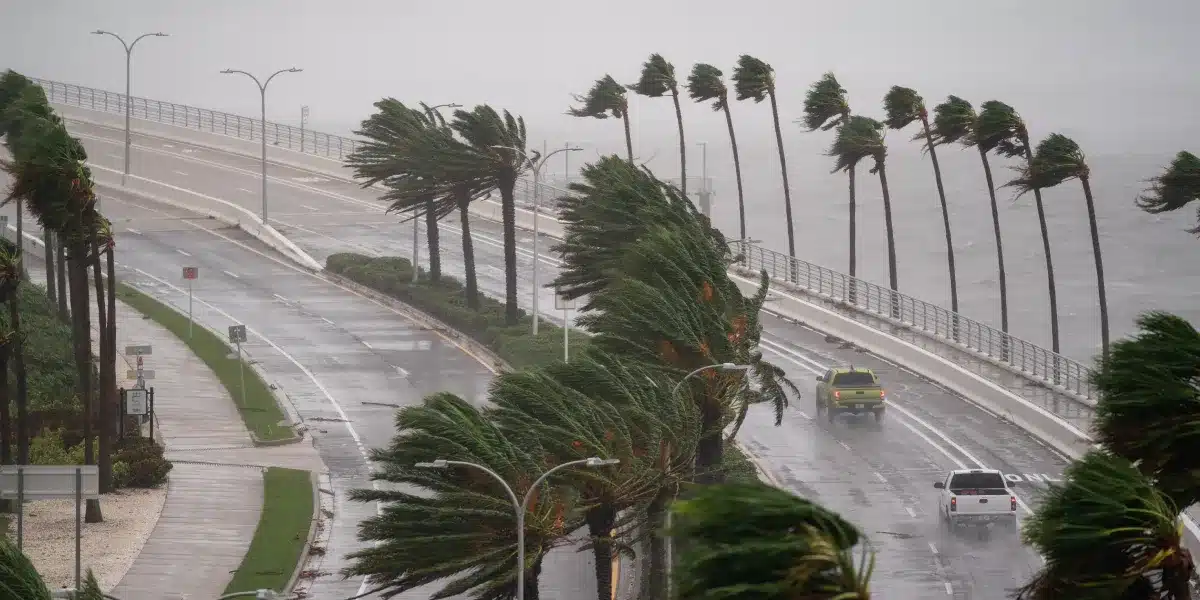
Forecasters have issued a Coastal Flood Watch, stating that portions of North Carolina Highway 12 may become unusable for days due to coastal overwash. 15 to 20 foot breaking waves are predicted, which have the power to demolish dunes, erode coastlines, and flood roadways.
Ocracoke Island received a similar proclamation from the Hyde County Board of Commissioners. As part of the state of emergency, locals had to evacuate starting Tuesday morning and tourists had to leave right away.
“The system will continue to increase in size and is forecast to bring life-threatening impacts to the Ocracoke coastline and render Highway 12 impassable,” the board stated.
Officials cautioned that once the island is shut off, emergency medical supplies could not be accessible and that protecting dunes could be destroyed by towering surf that exceeds 20 feet. While routes are still open, residents who require medical attention are encouraged to leave.
Tropical Storm Chantal in July provided as a reminder of how rapidly things may deteriorate along the Carolina coast, and Erin poses a threat offshore.
Early on Sunday, Chantal, a tropical storm, made landfall between Wilmington, North Carolina, and Charleston, South Carolina. Shortly thereafter, the Weather Prediction Center (WPC) and NHC reduced it to a tropical depression.
As the system proceeded onshore, it created hazardous conditions in areas of the Southeast United States.
Chantal was roughly 65 miles southwest of Raleigh, North Carolina, with sustained winds of 30 mph as of 5 p.m. EDT. At 10 mph, it was heading north-northeast, and through Monday, it was predicted to pick up speed in that direction.
Conditions were unstable in coastal areas from Surf City, North Carolina, to the South Santee River, South Carolina, and a tropical storm warning was in place.
At Apache Pier in South Carolina, continuous winds of 45 mph were recorded earlier in the day, with wind gusts reaching 50 mph.
Central North Carolina and south-central Virginia were under inland flash flood watches, with rain totals of 2 to 4 inches, with isolated locations possibly receiving up to 6 inches. Localized flooding might have resulted from these amounts, especially in low-lying and urban regions.
As the storm’s rainbands moved across eastern North Carolina, a tornado watch was issued for the area, warning of the possibility of localized tornadoes.
From northeastern Florida to the Mid-Atlantic states, life-threatening surf and rip current conditions persisted along the shoreline, prompting advisories for coastal residents and beachgoers.
Forecasters followed Chantal as it moved inland and urged locals in impacted areas to keep an eye on official bulletins and heed emergency protocols.
Residents were advised by officials to get ready for possible evacuations and prolonged emergency situations. The U.S.
Department of Homeland Security’s official emergency preparedness website, Ready, advised people to first identify the unique threats that their neighborhood faces.
Officials urged citizens to use the Federal Emergency Management Agency’s (FEMA) National Risk Index to determine the most likely dangers in their area, as local hazards ranged greatly, from storms and floods to wildfires or power outages.
Having a well-defined evacuation plan in place prior to an event was a crucial component of disaster preparedness.
This involved choosing a number of secure locations, such as hotels, public shelters, or friends’ or family members’ homes, and determining primary and backup evacuation routes via regional emergency management organizations.
Since most shelters only accepted service animals, pet owners also made plans in advance.
It was equally important to put together an emergency supplies kit, or “go-bag.” A few days’ worth of non-perishable food, a flashlight, a weather radio that could be operated by hand or by batteries, extra batteries, a first aid kit, hygiene supplies, and at least one gallon of water per person per day were all included in this pack.
Prescription drugs, a phone charger and backup battery, cash, critical documents, face masks, a manual can opener, and supplies for babies, elderly people, or pets, if any, were additional necessities.
These things ought to be kept in a place that all members of the household are familiar with and packaged in durable, portable containers.
In order to guarantee access wherever people were in the event of a disaster, Ready also advised keeping different kits in cars, at home, and at work.
Because gas stations may close or lose electricity during emergencies, citizens should prepare their vehicles by filling up their tanks before leaving.
It is recommended that homeowners only unplug appliances, secure windows and doors, and turn off utilities when directed to do so.
Residents departed early when authorities issued evacuation orders in order to avoid becoming stuck in traffic or water. Those without a means of transportation made advance arrangements with neighbors or municipal authorities.
Ready recommended securing the house, taking the go-bag, and only using approved routes during an evacuation. Shortcuts could be closed.
It’s important to stay informed. The FEMA App, which is accessible on cellphones, offers hazard updates, open shelter sites, and real-time warnings.
For emergency instructions, officials also advise listening to a battery-operated radio. Residents should leave a note for people at home and, if possible, notify an out-of-state contact of their destination.
Following evacuation, residents were encouraged to return home only if local officials deemed it safe to do so, particularly for those who had departed before the storm.
Power outages, service interruptions, and dangerous situations, such downed power lines or storm debris, may continue present threats in impacted areas, according to federal preparedness guidelines
Officials in charge of emergency preparedness stress that making plans in advance not only improves safety but also lessens pandemonium in times of emergency.